Applied Learning and Research Department: Advancing Conservation Science and Research Collaboration
The Applied Learning and Research Department (ALRD) at the Southern African Wildlife College (SAWC) has had an eventful quarter, marked by key engagements, research initiatives, and knowledge-sharing platforms.
Workshop Highlights – Johannesburg Session
By Natashia Khosa – Administrative Coordinator
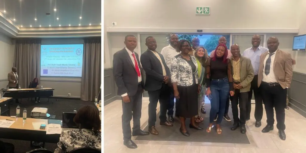
On 13 February 2025, the SAWC hosted a Workshop Guideline Validation Session at Birchwood Hotel in Johannesburg through the Research and innovation in Natural resource management and Waste management in Southern Africa (RiNaWa) project. The workshop focused on refining and validating the draft guidelines for research mentorship and academic support in Natural Resource Management (NRM) and Waste Management (WM).
Project consultants Msafiri Mkhondo and Casper Bonyongo led the session and were joined by key project partners from Zambia, Tanzania, Malawi, and Mozambique. Each country was represented by two specialists, including university professors with environmental and resource management expertise.
The SAWC team, including Project Manager Jenny Newnham, Dr Kudakwashe Musengi, and Natashia Khosa, played a key role in coordinating discussions and ensuring meaningful engagement. The invited partners reviewed the draft guidelines, offering expert recommendations to address challenges faced by researchers in tertiary institutions. Their insights will contribute to refining the guidelines before their final publication.
Once validated, the guidelines will serve as a structured resource for universities to improve research mentorship, mitigate common research challenges, and enhance regional conservation research.
Science Café Highlights in Maputo and Lilongwe
By Natashia Khosa – Administrative Coordinator
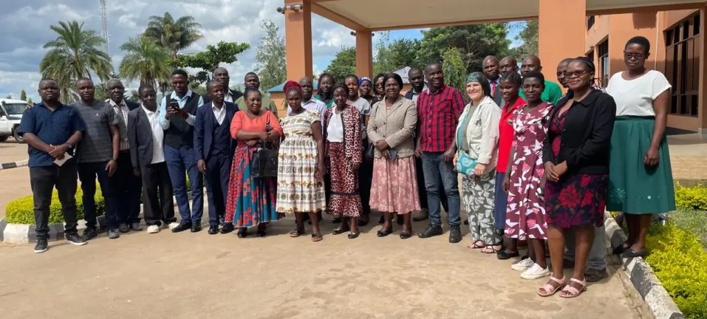
Under the RiNAWA project, the ALRD successfully hosted Science Café sessions in two target countries: Maputo, Mozambique, on 18 March and Lilongwe, Malawi, on 20 March. These sessions brought together key stakeholders, including community forums and organisations working within the landscape, to discuss ongoing projects in NRM and WM.
The discussions aimed at knowledge exchange, offering mutual support, and providing scientifically driven solutions to challenges within these sectors. The SAWC’s presentation on the final draft of the Guidelines for Mentoring Research and Supporting Tertiary Institutions in NRM and WM was a significant highlight. These guidelines, validated as a key resource, seek to enhance research mentorship and improve conservation efforts across the Southern African Development Community (SADC) region.
The SAWC presentation was delivered by Dr Kudakwashe Musengi and Dr Thabang Teffo, who elaborated on the significance of the guidelines in strengthening research and academic collaboration. Project Manager, Jenny Newenham, provided an overview of the project’s objectives, while Administrative Coordinator, Natashia Khosa, facilitated discussions and documented key insights.
The Science Cafés proved to be instrumental in fostering knowledge exchange, strengthening partnerships, and improving collaborative efforts to address the region’s environmental challenges. The input gathered from these sessions will refine the guidelines and ensure their practical application in supporting research and policy development in NRM and WM.
The Importance of GIS and Topographic Maps
By Cliford Nxumalo – Project Research Assistant/Researcher
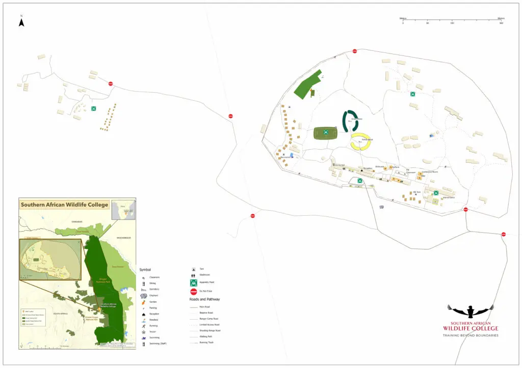
The SAWC is situated in the Kempiana Nature Reserve within the Greater Kruger National Park in South Africa. This diverse landscape, comprising savannahs, rivers, and woodlands, requires precise environmental planning and navigation tools.
Topographic maps are essential for various conservation activities, offering detailed representations of physical and human-made features. These maps, which use contour lines, symbols, and colour-coding, play a crucial role in:
- Wildlife Conservation: Understanding landscapes for effective tracking and protection of wildlife.
- Navigation: Assisting researchers, students, and rangers in safe movement across the reserve.
- Environmental Management: Supporting sustainable land-use planning.
- Emergency Response: Identifying key facilities and evacuation routes in case of incidents.
The SAWC topographic map is a valuable tool for conservationists, researchers, and students. Additionally, the College offers a Geographic Information Systems (GIS) Training Course at National Qualifications Framework (NQF) Level 6, equipping participants with advanced spatial analysis skills.
Innovative Research on Reptile-Centric Camera Traps
By Cliford Nxumalo – Project Research Assistant/Researcher
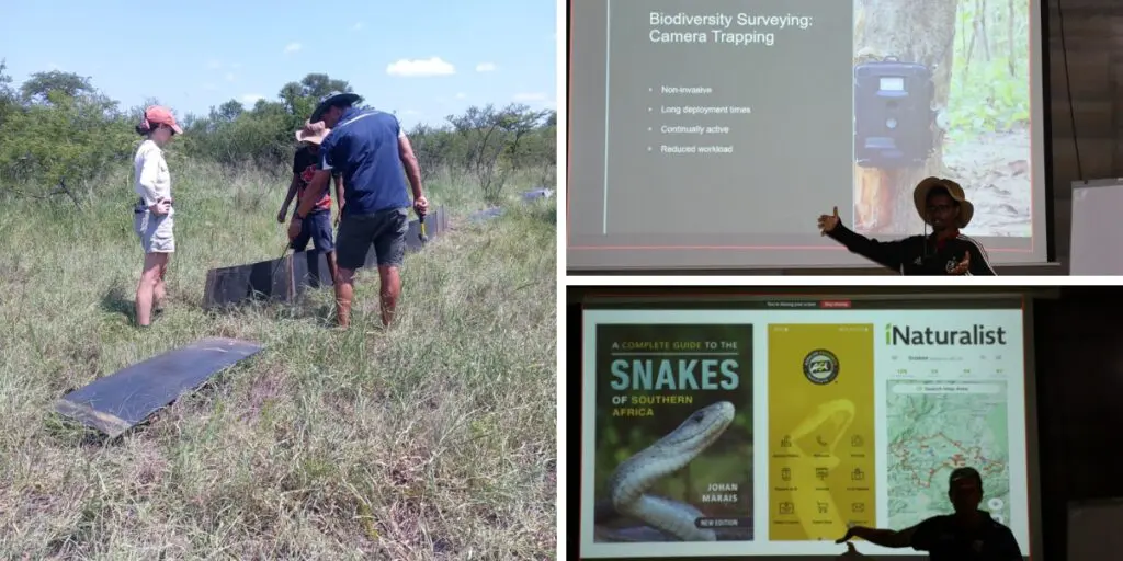
Samkelo Mbovane, a Masters student from the University of the Western Cape, presented his research on assessing the effectiveness of newly designed reptile-centric camera traps to the SAWC staff on 14 February 2025. His study focuses on overcoming the limitations of traditional Passive Infrared (PIR) camera traps, which struggle to detect reptiles due to their lower body surface temperature.
Mbovane’s project involves testing specialised camera traps designed for passive reptile detection. These traps are deployed across the SAWC, accompanied by drift fence arrays and continuous video monitoring to assess their reliability. His research highlights the advantages of modern camera-trapping techniques in biodiversity monitoring and reptile conservation.
The findings from this study could revolutionise reptile research by providing more accurate, non-invasive monitoring tools, ultimately contributing to broader conservation efforts.